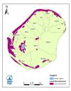
Locality of Nauru Island hydrology feature -…

The Nauru Department of Commerce, Industry and Environment has oversight and responsibility over issues concerning the environment, climate change, and commerce.
NRC has the mandatory obligation of Nauru Parliament to implement, initiate and coordinate the rehabilitation and development of the mined out lands of Nauru. NRC is also managing the only dumpsite in Nauru where industrial, commercial and household waste are dumped.
License
Map of the Nauru Island hydrology feature, Buada Lagoon and areas of land development.
Data and Resource
| Field | Value |
|---|---|
| Publisher | Nauru Department of Commerce, Industry and Environment, Nauru Rehabilitation Corporation, Secretariat of the Pacific Regional Environment Programme |
| Modified | |
| Release Date | |
| Identifier | e0399864-c2ff-4f0c-a524-8d9d888c079d |
| Spatial / Geographical Coverage Location | Nauru Island |
| Relevant Countries | Nauru |
| Language | English (Canada) |
| License |
SPREP Public Licence
![[Open Data]](https://assets.okfn.org/images/ok_buttons/od_80x15_blue.png)
|
| Author | SPREP |
| Contact Name | Vani Koroisamanunu |
| Contact Email | vanik@sprep.org |